 Filter: Categories of Wisconsin Historical Images
Filter: FORMAT_DIMENSIONS of 56 cm
Filter: Categories of Wisconsin Historical Images
Filter: FORMAT_DIMENSIONS of 56 cm

| Date: | 1780 |
|---|---|
| Description: | Contenant: New Hampshire, Massachusetsbaye, Rhode Island, Connecticut, La Nouvelle York, Nouvelle Jersey, La Pensilvanie, Les Comtes de Newcastle, Kent et ... |
| Date: | 1976 |
|---|---|
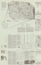
| Description: | This is a guide to the original bikeway and additions. The front of the guide includes a map of Wisconsin, a map of the entire bikeway, and one route map. ... |
| Date: | 1976 |
|---|---|
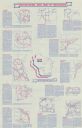
| Description: | Intended for tourists, the front of this guide includes twelve county bicycle maps and text. The reverse includes four maps of state trails and nine maps o... |

| Date: | 1914 |
|---|---|
| Description: | Two maps of northern Wisconsin counties of Ashland, Barron, Bayfield, Chippewa, Douglas, Forest, Iron, Langlade, Lincoln, Oneida, Polk, Price, Sawyer, Tayl... |

| Date: | 1883 |
|---|---|
| Description: | This birdseye view map reads: ""MERRILLAN JACKSON COUNTY, WISCONSIN. LOOKING FROM POSITION NORTH EAST ON THE TOWN." At the bottom are points to interest th... |
| Date: | 1956 |
|---|---|
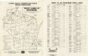
| Description: | A map that identifies the trout lakes in Wisconsin and their proximity to cities. Text on the page of the map highlights the conservation actions taken by ... |

| Date: | 1895 |
|---|---|
| Description: | Color lithograph poster whose top caption reads "Oscar F. Hodge presents" followed in larger type by "Neil O'Brien and His Great American Minstrels." Below... |

| Date: | 1860 |
|---|---|
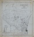
| Description: | A survey map of Wisconsin, southeastern Minnesota, and northern Iowa, showing the status of surveys, rivers, and lakes. The map also shows the locations of... |

| Date: | 1836 |
|---|---|
| Description: | This hand-colored manuscript map shows the township and section grid in southeastern Wisconsin, covering the area west to Sugar River and Four Lakes region... |

| Date: | 1848 |
|---|---|
| Description: | Wisconsin became the thirtieth state in 1848. Drawn that same year, this map shows township lines, roads, villages, mills, railroads, prairies, swamps, can... |

| Date: | 1851 |
|---|---|
| Description: | Map outlines mid and southern Wisconsin county boundaries in blue, and city/town lines are provided. Other marks include mines, plank roads, and railroads. |

| Date: | 1920 |
|---|---|
| Description: | This early road map shows the system of roads in Wisconsin, northern Illinois, northeastern Iowa, southeastern Minnesota, and the western portion of Michig... |

| Date: | 1936 |
|---|---|
| Description: | This 1936 Wisconsin Conservation Dept. map shows the locations of state forestry Civilian Conservation Corps (CCC) camps, closed state forestry CCC camps, ... |

| Date: | 1950 |
|---|---|
| Description: | This road map shows federal, state and county roads in Wisconsin, northern Illinois, northeastern Iowa, eastern Minnesota, and the western portion of Michi... |
| Date: | |
|---|---|
| Description: | A map indicating the population density of German-born people in Wisconsin based on the 1905 census. The map shows the county boundaries throughout the sta... |

| Date: | 1975 |
|---|---|
| Description: | A tourist map of Grant County that displays the various activities and attractions found in the cities throughout the county, such as boat landings, fishin... |

| Date: | 1955 |
|---|---|
| Description: | Bottom of the map reads: "PARKING AREA STUDY MILWAUKEE COUNTY ZOOLOGICAL GARDEN SCALE 1"=200" APRIL 21, 1955 TOTAL PARKING AREA - 3736 CARS 31.1 acres". Th... |

| Date: | |
|---|---|
| Description: | Map of northern Iron County, Wisconsin, shows town sections and railroads in the towns of Saxon, Kimball, and Gurney. It also includes the area of the La P... |

| Date: | |
|---|---|
| Description: | An ink and water color on paper, hand-drawn map showing the section divisions in the southern half of the Janesville Township (Township 3 North, Range 12 E... |

| Date: | 1946 |
|---|---|
| Description: | A map showing the roads, railroads, towns, cities and villages, streams and lakes, airports, schools, churches, cemeteries, and golf courses in Kenosha Cou... |
If you didn't find the material you searched for, our Library Reference Staff can help.
Call our reference desk at 608-264-6535 or email us at: